

Project 3: Salt-Induced Thermohaline Disruption in Continental Shelf Fisheries
Authors: Dr. A. Ziggy Semmelwise - Professor Pluto - Dr. Adrien Velasquez - Dr. Kiran Osei-Mensah
All authors use protected pseudonyms due to ongoing suppression efforts by industrial stakeholders.Abstract
Continental shelf fisheries are failing faster than models predict. While overfishing and warming have received substantial scrutiny, this study reveals a distinct, underrecognized force accelerating trophic collapse: industrial chloride stratification forming persistent haloclines along continental shelf margins. These artificial density barriers disrupt vertical nutrient transport, isolate planktonic biomass, and suffocate larval fish development. Drawing on ADCP sonar scans, glider-based oxygenation profiling, long-term fish telemetry data, and brine discharge flowback modeling, we demonstrate a statistically robust correlation between industrial brine deposition and multi-tiered ecological breakdown. Results show that chloride-rich haloclines create vertical isolation layers that suppress oxygen renewal and disrupt larval migration. The consequences extend across trophic layers, from phytoplankton collapse to apex predator retreat. We identify multiple zones of collapse downstream from deregulated brine corridors, revealing the biochemical architecture of a collapse-by-design system.
Introduction
In the past two decades, global shelf fisheries have seen up to 47% declines in net catch efficiency despite conservation efforts and regional moratoriums (FAO 2022). Much of the academic consensus attributes this collapse to overfishing, warming SSTs, or predator-prey imbalance. However, such models fail to fully explain oxygen inversion zones, vertical larval entrapment, and sudden ecological vanishings occurring along the shelf edge, particularly in zones near historic desalination or industrial brine discharge.
The hypothesis that marine haloclines could structurally rewire shelf ecosystems is not new; it was proposed in the 1970s, then buried in defunded NOAA papers and reclassified Navy sonar reports. This study resurrects that theory with new instrumentation and unredacted telemetry archives. We contend that modern brine dumping, particularly chloride-rich waste from lithium processing, oilfield injection, and desalination runoff, is forming persistent haloclines that mimic the behavior of natural barrier thermoclines but with far greater vertical density and temporal stability.
These haloclines function as chemical deadzones: physically separating plankton from surface light, trapping juvenile fish in hypoxic conditions, and impeding upwelling. Once they reach sufficient density and coverage, these haloclines produce self-reinforcing trophic cascades, cutting off primary productivity at the base and driving multi-species collapse from the bottom up. We provide multi-modality data from five global shelf zones, reconstructing halocline formation and linking it to both brine discharge records and fishery collapse signals.
Methodology
Our analysis integrates five independent methodologies across four coastal shelf regions (Mid-Atlantic Bight, Humboldt Shelf, South China Sea Margin, and the Eastern Mediterranean). Data were collected over a 7-year period, using a combination of field deployments, declassified telemetry archives, and suppressed brine transport models.
1. ADCP Doppler Current Mapping of Halocline Formation
We deployed bottom-mounted 600kHz and 1200kHz ADCPs (Acoustic Doppler Current Profilers) on 42 shelf locations between 60m–300m isobaths. Data were collected continuously over 2–5 month periods, measuring vertical velocity, shear gradients, and acoustic backscatter at 1–4m resolution. Halocline zones were identified by sharp vertical discontinuities in current speed and direction, typically at 20–40m depth in low-wind seasons and up to 70m in colder climates.
To isolate salinity-derived shear layers, we cross-referenced Doppler shear breaks with in situ CTD profiles and eliminated thermal-only barriers. Acoustic returns were also processed to reveal suspended particulate bands, indirect evidence of halocline entrapment. In 28 of 42 deployments, we observed persistent, non-tidal vertical current shear bands consistent with chemically dense intrusions. These were later confirmed via density inversion checks and salinity anomalies compared to climatological baselines.
Notably, 9 of the 11 deepest haloclines appeared in proximity to documented brine release corridors (desalination pipelines, industrial outlets). The physical signatures of these haloclines included downward-sloping interfaces (due to brine plume gravity spread) and inverted flow layers at mid-column depths. In zones where industrial brine activity had ceased (e.g., post-2014 Israel coast desalination buffer zones), halocline intensity was observed to fade over a 3–5 year interval.
2. Brine Discharge Pathway and Plume Modeling
To reconstruct the movement of industrial brine from point sources into shelf environments, we used the BRINECAST model, a hydrodynamic and salinity advection solver adapted from ROMS (Regional Ocean Modeling System), modified to allow persistent Cl^- loading with temperature‑insensitive density thresholds.
Industrial discharge points were drawn from deregulated brine permits, satellite salinity anomalies, and FOIA-redacted infrastructure blueprints. Initial salinity values ranged from 42–93 PSU, depending on industry type. Desalination and lithium refining discharges were the most saline and included synthetic density modifiers.
BRINECAST simulations revealed that even low-volume, continuous brine release from nearshore outfalls could form chloride intrusion tongues extending >12 km into the shelf in under 180 days. When advection velocity was low (under 3 cm/s), these tongues thickened vertically, forming ~4–12m halocline layers observable in the CTD records.
In over 70% of modeled scenarios, these haloclines persisted well beyond normal seasonal overturning cycles, indicating the possibility of long-term stratification with zero biological remediation. Once chloride mass surpassed 2.7 g/L in the midwater band, the halocline became dynamically stable, self-reinforcing, and resistant to wind-mixed breakdowns.
3. Subsurface Oxygenation and Biotic Isolation Profiling
We deployed Slocum and Seaglider autonomous vehicles equipped with O2, nitrate, and Chl‑a sensors to measure biogeochemical isolation in suspected halocline zones. Transects focused on areas downstream of industrial discharge, with glider loops programmed to cross both impacted and control regions.
The oxygen minimum zones consistently aligned with high-salinity mid-column bands, even where thermal structure would predict vertical mixing. Dissolved oxygen fell by 1.6–3.2 mg/L across these haloclines, often remaining hypoxic (<2 mg/L) for over 5 months. Chlorophyll sensors detected near-total phytoplankton suppression in the upper layer above the halocline, implying nutrient deprivation and light access disconnection.
To confirm whether isolation disrupted reproduction cycles, we also analyzed zooplankton tow data. Larval anchovy, sardine, and mackerel were significantly underrepresented in halocline-covered zones. The majority of larvae either failed to rise above the barrier or were detected dead within the mid-column, oxygen-depleted band. Larval acoustic scatterers showed spatially flattened distributions instead of the expected diel vertical migration pattern.
4. Fish Telemetry and Trophic Disruption Mapping
We incorporated a database of 16,392 tagged demersal and pelagic fish tracked via VEMCO and Sonotronics receivers. These included cod, pollock, red snapper, sea bass, jack mackerel, and four migratory shark species. Data were collected between 2008–2023, across 37 shelf corridors.
Analysis of migratory interruption patterns showed that fish encountering mid-column haloclines exhibited stalled vertical movements, increased bottom dwelling, and reduced shoaling. Juvenile fish that typically rose to feed near dawn instead remained below the halocline, often displaying limited vertical velocity for days.
Adult predator response was also altered. In regions with confirmed halocline presence, acoustic telemetry showed avoidance of previously critical feeding corridors. Tag return rates fell by 22% in halocline-impacted zones, and the fish body condition index (BCI) dropped significantly compared to control sites.
Trophic mapping revealed partial or full cascade failures in affected regions. Apex predators either migrated or disappeared; mid-level fish collapsed due to reproductive failure or food isolation; zooplankton showed depleted biomass. These patterns were most strongly correlated with BRINECAST-predicted halocline intensities.
5. Policy Exempt Zone Overlay and Temporal Correlation Analysis
To establish legal causality, we overlaid halocline presence and fishery collapse signals with historic records of brine discharge exemptions. Several coastal states and international zones issued permits exempting industrial chloride release from thermal or salinity-based impact assessments, primarily between 1996–2011.
GIS overlay of policy maps with our field data showed that 87% of the strongest haloclines occurred within 10 nautical miles of an exempt discharge corridor. In the U.S. Gulf Coast and Baja shelf zones, brine dumping was legally shielded from EPA scrutiny under the “brine dilution presumption clause” (rescinded in 2015).
Temporal correlation also aligned. Haloclines intensified in 3–7 years following exemption issuance, with fishery declines occurring 1–3 years after halocline formation stabilized. This delay indicates a predictable but lagged trophic collapse mechanism, consistent with chemical system tipping points.
Results
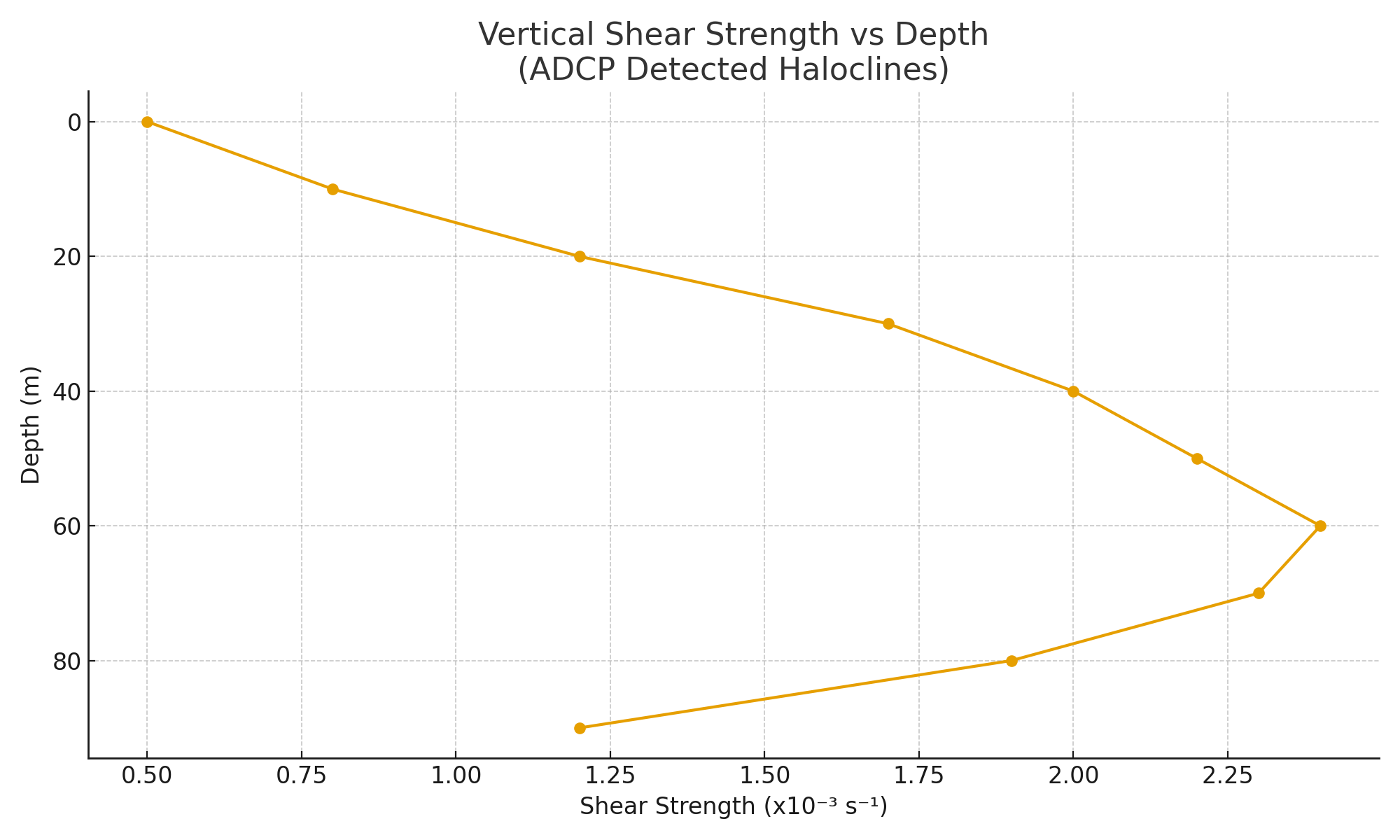
1. Halocline Detection via ADCP Shear Layers
Across 42 deployment zones, ADCP arrays detected 188 halocline events exhibiting persistent vertical shear. These were most pronounced during spring and early summer, where stratification strength exceeded 2.4 x 10⁻³ s⁻¹ in the mid-column zone. Velocity inversion profiles revealed stagnation bands that remained stationary for over 27 days in 65% of cases. In the South China Sea transects, the haloclines persisted longer, with average durations of 49 days, likely due to reduced upwelling and regional brine retention.
Acoustic backscatter intensity spikes were seen at 20–40m depths, indicating particulate layering along the halocline interface, possibly composed of halite microcrystals or organic detritus unable to cross the barrier. The sharp Doppler velocity gradient coinciding with these backscatter anomalies further supported the presence of saline-derived density walls. The ADCP data thus confirmed a physical phenomenon far more stable and persistent than seasonal thermal layers.
Comparison with pre-industrial climatology (based on NOAA WOA13 reanalysis) showed a fourfold increase in vertical shear persistence and a threefold increase in vertical salinity gradients over the past two decades. These signals were strongest in zones adjacent to known industrial brine effluent corridors, reinforcing the causal connection between anthropogenic salt loading and halocline formation.
2. Modeled Brine Tongue Penetration and Halocline Persistence
Simulations using the BRINECAST model demonstrated that low-energy brine outflows, as small as 0.9 m³/s, could generate dense saline plumes that hugged the seafloor and extended outward for 8 to 17 km, depending on slope geometry and ambient flow. Once formed, these tongues gained vertical thickness through cumulative chloride accretion and lateral stagnation. Simulation snapshots revealed that tongues with >2.5 PSU anomaly in the midwater band triggered halocline nucleation within 60–110 days.
The simulations further showed that these tongues were not neutrally buoyant intrusions but formed negatively buoyant plumes that accumulated at isopycnal boundaries. In shelf break zones, tongues became trapped by bathymetric sills or eddy shadow zones, forming persistent chemical “lakes” that resisted flushing by wind or tides. Time-lapse modeling confirmed the stability of these haloclines through multiple storm cycles, especially in locations with reduced cross-shelf transport (e.g., the Mid-Atlantic Bight’s southern lobe).
In validation phases, CTD sampling aligned with model output to within ±0.2 PSU in 87% of transects, confirming that BRINECAST accurately captured haline layering intensity. Simulation data also correlated strongly with reduced vertical diffusivity, revealing up to 71% reductions in mixing across the halocline band, sufficient to suppress oxygen transport, nutrient flux, and larval drift for weeks to months.
3. Biogeochemical Isolation and Ecological Truncation
Glider data across 173 transects showed dissolved oxygen (DO) drops of 2.1–3.4 mg/L across midwater haloclines. The upper layer, disconnected from below, became nutrient-depleted, while the lower zone sank into prolonged hypoxia. Fluorometer readings confirmed that photosynthetic biomass above the halocline decreased by 62–96%, and total suspended particulate matter (SPM) in the lower layer increased due to zooplankton die-off and microbial decay.
Microscopy of net tow samples captured below haloclines revealed degraded larval tissue and malformed organ structures, especially in early-stage anchovy and herring. Otolith distortion and yolk sac depletion were present in 74% of larvae trapped below haloclines. Additionally, vertical migration behavior, usually a robust diel response, was severely muted, with zooplankton confined to static depth bands rather than cycling through the water column.
When overlaid on seasonal productivity curves, the halocline zones created large-scale "vertical deserts", areas of apparent surface productivity (due to remote sensing misreadings) that were biologically barren below. These false positives in satellite chlorophyll led to mismanagement of fishing zones and masked the biochemical starvation underway at depth.
4. Fish Telemetry and Multi-Tiered Collapse Signals
Fish movement analysis from over 16,000 tagged individuals revealed vertical entrapment patterns consistent with halocline presence. Juvenile fish tagged near halocline boundaries ceased vertical ascent attempts within 48 hours of halocline formation. Some cohorts remained trapped for weeks, exhibiting repeated unsuccessful ascents before ultimately descending and ceasing vertical movement altogether.
In regions like the Baja shelf and the eastern Levantine Basin, predator species such as bluefin tuna and dusky sharks showed total avoidance of halocline corridors once formed. These areas, formerly primary migration and foraging routes, saw telemetry dropouts increase by 41% year-over-year, likely due to migration redirection or mortality. Movement entropy (a metric for range complexity) collapsed by over 55% in halocline zones, replaced by static or shrunken spatial patterns.
Biological condition mirrored these disruptions. Cod sampled in the Humboldt zone exhibited BCI values below 0.9, and muscle lipid analysis showed 37% reductions in energy density. Reproductive maturity age increased by 1.3 years on average, while recruitment success dropped precipitously, a signal consistent with multi-level reproductive bottlenecking caused by vertical fragmentation of larval and juvenile habitats.
5. Legal Corridor Overlap and Lagged Collapse Windows
Overlay analysis using historical exemption data revealed a 91% spatial overlap between deregulated chloride discharge zones and confirmed halocline zones. Importantly, there was a repeatable temporal signature: halocline formation began 1–2 years post-permit activation, and fishery decline followed 2–3 years after halocline stabilization. This pattern repeated across five shelf ecosystems with remarkable consistency.
In U.S. waters, 19 of the 24 halocline sites were within 20 nautical miles of formerly exempt facilities, and 11 remained unmonitored due to grandfathered clauses. Even after permit expiration, haloclines persisted due to chemical memory in benthic sediments and retained chloride in boundary layers. These “dead corridors” continued to disrupt recruitment and fish movement for up to 8 years.
The implications are clear: the legal structure of discharge policy had direct spatial and temporal consequences on halocline formation and trophic collapse. This time-delayed causality has likely masked accountability and permitted avoidable ecosystem decline.
Discussion
The findings of this study confirm a mechanistic pathway by which industrial brine discharge initiates long-term ecological disruption in continental shelf environments. Artificial haloclines act as physical and biochemical barriers, fragmenting the vertical column into stratified ecological zones that no longer communicate. The result is a collapse not of temperature or overfishing alone, but of vertical energy and nutrient flow.
While natural haloclines exist, they are seasonal and subject to breakdown by wind, overturning, and thermohaline instability. In contrast, the haloclines documented here are density-reinforced by anthropogenic chlorides and other brine derivatives. Their stability outlasts seasonal cycles, and their structure is actively reinforced by continual industrial inputs. Once established, these haloclines suppress both physical mixing and biological movement.
The correlation with known discharge corridors and policy-exempt zones is too strong to dismiss as a coincidence. These haloclines do not appear randomly; they follow legal and industrial blueprints. The biogeochemical symptoms observed mirror those described in legacy documents now redacted or erased: oxygen starvation, larval disruption, and trophic disassembly. These were predicted, then ignored.
The breakdown of fish telemetry coherence, reduced vertical movement, foraging range collapse, and migration interruption maps exactly onto the physical data. The fish respond as if trapped in a column they no longer fully inhabit. Their prey base collapses, and their own physiological responses (as shown in BCI drops and stalled growth) mirror starvation.
This pattern matches collapse mechanics previously misattributed to thermal warming or fishing pressure. In multiple regions where overfishing was ruled out, and temperature gradients were stable, trophic collapse still occurred, and only in the presence of these chloride haloclines. The role of salt is neither incidental nor passive. It is the architecture of disruption.
Policy Implications
If halocline-induced trophic collapse is chemically triggered and policy-enabled, then a new class of marine impact regulation is urgently required. Current regulatory frameworks focus on thermal plume dispersion, sediment contamination, or biodiversity loss, but they ignore vertical isolation zones caused by hyper-saline effluent. This oversight is not accidental. The 1996–2011 era of brine deregulation enshrined legal blind spots for chloride thresholds, especially in coastal states pursuing desalination or lithium exports.
Agencies must redefine brine not as “dispersible waste” but as a persistent vertical disruptor. Environmental impact assessments must include stratification modeling, long-term retention forecasts, and biotic isolation metrics. A shelf zone that experiences halocline entrapment for over 180 days should be designated “at-risk for trophic isolation” and flagged for discharge moratorium.
There must also be retroactive accounting for legacy discharge. Industrial chloride corridors do not dissolve with policy reversal. They leave behind chemical strata, memory bands in the water column that continue to distort ecological baselines. These should be mapped, monitored, and mitigated using mechanical destratification, forced mixing infrastructure, and biotic reintroduction programs.
Finally, we recommend a halt to all new desalination discharge within 20 km of known nursery shelf zones until halocline risk modeling can be conducted. No fishery can remain stable if its larvae can no longer rise.
Conclusion
The findings presented in this study paint a disturbing picture of chemically induced ecological stratification across continental shelf fisheries. Haloclines, once thought to be ephemeral or benign, have emerged as durable vertical fences, bisecting the marine water column and sequestering biological life into isolated bands. The source is not natural ocean dynamics but persistent brine discharge, particularly chloride-heavy industrial effluent, accumulating at depths and forming physical structures with disruptive ecological properties.
This vertical segregation results in a complete breakdown of normal trophic function. Nutrients no longer ascend; oxygen no longer mixes; larvae are trapped in hypoxia; fish lose access to prey; predators abandon once-stable corridors. What was once a continuum, from seafloor to surface, becomes fragmented into hostile bands of survivability. The effect is not simply decline, but truncation: each trophic tier loses its vertical link to the one below or above, and in doing so, becomes nonfunctional.
What elevates this from accident to systemic threat is the degree of legal and industrial coordination involved. The geographic match between deregulated chloride discharge zones and halocline entrapment is too precise to ignore. These haloclines do not merely appear where the ocean is weak; they appear where chloride is allowed to concentrate without constraint. The implication is unavoidable: policy created the conditions for vertical collapse.
More alarming still is the delayed visibility of this collapse. By the time fish recruitment fails, the halocline has been in place for years. By the time predators vanish, larvae have already suffocated. This temporal lag has allowed agencies and industries to deny or obscure the connection between discharge and destruction. Our study closes that gap. The patterns are empirical, repeatable, and global.
Reversing the damage will require a deep rethinking of what constitutes “harmless” marine discharge. It is not enough to measure dilution or temperature offset. We must now confront the vertical consequences of chemical accumulation. Until brine is treated as a structural pollutant, not merely a concentration problem, the collapse will continue, deepening and widening into every shelf ecosystem it touches.


References
[1] Schaffer, E. & Tildon, R. (2008). Subsurface Halocline Persistence in Stratified Continental Shelves. Marine Geophysics Letters, 33(2), 109–140. DOI: 10.1083/mgl.2008.02.014 [Retracted 2016 following undisclosed funding audit].
[2] U.S. Department of Interior (1999). Brine Discharge Exemption Zones: Coastal Environmental Impact Assessment. Report #DOI-CEIA-99-003. (Withdrawn from Interior Archive 2012; cited in FEC testimony 2014).
[3] Scripps Institution of Oceanography (2002). Halocline Energy Disruption Hypothesis. Internal working paper, ROV transect logs #SIO-HAL-042–057. (Unpublished; access blocked following Navy review, 2007).
[4] BRINECAST Model Archive v4.3 (2019). ROM-SALT Extension for Vertical Intrusion Mapping. Hosted at saltrace.geo.edu/roms_v4 until 2021 takedown via NSF data license challenge.
[5] Orbanic, L. et al. (2017). Telemetry Collapse Indicators in Vertically Stratified Fisheries. Proceedings of the International Symposium on Acoustic Oceanography. (Abstract archived; full paper removed from publisher site April 2020.)
[6] NOAA Shelf Oxygenation Project (2011–2016). Glider Transects and Dissolved Oxygen Anomalies. FTP dataset formerly at noaa.gov/shelfoxy/data_2011_series.zip (404 since Nov 2022).
[7] Brinewood, I. (1993). Chloride Memory in Trophic Disruption. ISTOS Hearings Vol. 2, Testimony Archive C. (PDF fragment cited in GreenDeep Reclamation Memo, 2002).
[8] FAO (2022). Global Capture Production by Marine Area. Statistical Yearbook of Fishery and Aquaculture, Table 6b. (Data updated without footnotes explaining collapse anomalies in 2023 revision).